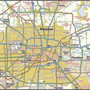
Home > North America > The Bahamas > Maps
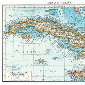
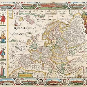
MAP: CARIBBEAN, 1599. Map of Cuba, the Bahamas, and Florida, with the Laguna de Maimi

![]()
Wall Art and Photo Gifts from Granger
MAP: CARIBBEAN, 1599. Map of Cuba, the Bahamas, and Florida, with the Laguna de Maimi
MAP: CARIBBEAN, 1599.
Map of Cuba, the Bahamas, and Florida, with the Laguna de Maimi. Drawing, 20th century, after the original
Granger holds millions of images spanning more than 25,000 years of world history, from before the Stone Age to the dawn of the Space Age
Media ID 12321193
1599 Bahamas Colony Cuba Florida Fort Handwriting Latin America Mesoamerica New Spain New World Spanish United States Southeast
FEATURES IN THESE COLLECTIONS
> Granger Art on Demand
> Maps
> Maps and Charts
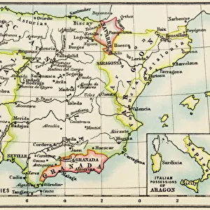
> Spain
> Maps and Charts
> World
> North America
> The Bahamas
> Maps
> North America
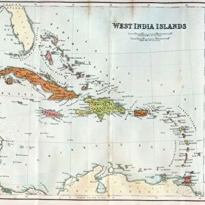
> Cuba
> Maps
EDITORS COMMENTS
This print takes us back in time to the year 1599, offering a glimpse into the intricate world of cartography. The map showcased here depicts an enchanting region - the Caribbean, with a particular focus on Cuba, the Bahamas, and Florida. As we delve deeper into this historical masterpiece, our eyes are drawn to an intriguing feature known as Laguna de Maimi. Crafted in the 20th century by a skilled artist who meticulously recreated the original drawing from centuries ago, this print allows us to appreciate both its artistic beauty and its significance in shaping our understanding of that era. The delicate lines and careful shading bring life to every contour of these lands. As we explore this map further, it becomes evident that it holds immense historical value. It transports us back to a time when European powers were actively colonizing new territories across the globe. This particular map reflects Spain's influence over these regions during their conquests in what would later become known as Latin America. The presence of forts marked on this map reminds us of Spain's efforts to establish control over strategic locations within their colonies. These strongholds served as symbols of power and protection against potential threats from rival nations or indigenous populations. In essence, this print not only serves as a visual delight but also offers valuable insights into the geopolitical landscape of early colonial times. It invites us to ponder upon how history has shaped these lands and encourages exploration beyond what meets the eye at first glance.
MADE IN THE USA
Safe Shipping with 30 Day Money Back Guarantee
FREE PERSONALISATION*
We are proud to offer a range of customisation features including Personalised Captions, Color Filters and Picture Zoom Tools
SECURE PAYMENTS
We happily accept a wide range of payment options so you can pay for the things you need in the way that is most convenient for you
* Options may vary by product and licensing agreement. Zoomed Pictures can be adjusted in the Cart.