Home > North America > United States of America > Washington, District of Columbia
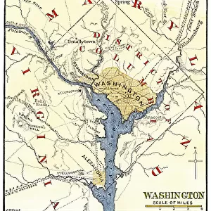
DISTRICT OF COLUMBIA, 1801. Plan of the District of Columbia, including the cities of Washington, Georgetown and Alexandria, according to the Organic Act of 1801. Wood engraving, 1886

![]()
Wall Art and Photo Gifts from Granger
DISTRICT OF COLUMBIA, 1801. Plan of the District of Columbia, including the cities of Washington, Georgetown and Alexandria, according to the Organic Act of 1801. Wood engraving, 1886
DISTRICT OF COLUMBIA, 1801.
Plan of the District of Columbia, including the cities of Washington, Georgetown and Alexandria, according to the Organic Act of 1801. Wood engraving, 1886
Granger holds millions of images spanning more than 25,000 years of world history, from before the Stone Age to the dawn of the Space Age
Media ID 7560117
1801 Alexandria Federal George Town Plan Potomac River Wood District Of Columbia
FEATURES IN THESE COLLECTIONS
> Granger Art on Demand
> Plans and Diagrams
> North America
> United States of America
> Washington, District of Columbia
EDITORS COMMENTS
This wood engraving from 1886 showcases the intricate plan of the District of Columbia in 1801. The print depicts a detailed map that includes the cities of Washington, Georgetown, and Alexandria, all designed according to the Organic Act of 1801. This historic artwork offers a glimpse into early America's federal landscape. The image highlights the strategic placement of these three significant cities along the Potomac River. Each city is meticulously represented with its own distinct layout and architectural features. From Washington's grand avenues to Georgetown's charming streets and Alexandria's bustling waterfront, this engraving captures the essence of each urban center. As you explore this remarkable piece, it becomes evident how much thought was put into designing this planned capital district. The careful arrangement reflects both functionality and aesthetics, showcasing an organized grid system that would later become iconic for American city planning. This wood engraving serves as a valuable historical artifact, providing insight into not only the physical layout but also the vision behind creating such a unique district. It allows us to appreciate how far we have come while honoring our nation's rich history. Displayed proudly in any collection or gallery space, this print from Granger Art on Demand invites viewers to delve into America's past and marvel at one of its most important urban developments –the District of Columbia.
MADE IN THE USA
Safe Shipping with 30 Day Money Back Guarantee
FREE PERSONALISATION*
We are proud to offer a range of customisation features including Personalised Captions, Color Filters and Picture Zoom Tools
SECURE PAYMENTS
We happily accept a wide range of payment options so you can pay for the things you need in the way that is most convenient for you
* Options may vary by product and licensing agreement. Zoomed Pictures can be adjusted in the Cart.