Home > Animals > Mammals > Cats (Domestic) > Russian Blue
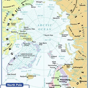
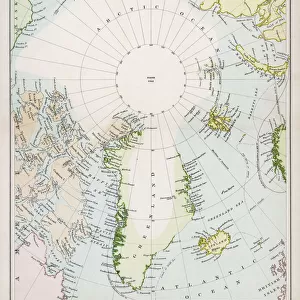
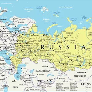
Digital illustration of map showing position of Arctic Ocean and surrounding continents

![]()
Wall Art and Photo Gifts from Fine Art Storehouse
Digital illustration of map showing position of Arctic Ocean and surrounding continents
Unleash your creativity and transform your space into a visual masterpiece!
Dorling Kindersley
Media ID 13541035
© This content is subject to copyright
Arctic Ocean Blue Background Canada Continent Iceland North America North Pole Russia Surrounding Western Script Digitally Generated Digitally Generated Image
FEATURES IN THESE COLLECTIONS
> Animals
> Mammals
> Cats (Domestic)
> Russian Blue
> Animals
> Mammals
> Muridae
> Western Mouse
> Arts
> Artists
> O
> Oceanic Oceanic
> Arts
> Street art graffiti
> Digital art
> Digital paintings
> Asia
> Related Images
> Europe
> Iceland
> Related Images
> Europe
> Related Images
> Fine Art Storehouse
> Photo Libraries
> Dorling Kindersley Prints
EDITORS COMMENTS
This stunning digital illustration captures the beauty and significance of the Arctic Ocean and its surrounding continents. The map, created by Dorling Kindersley, showcases the precise position of this icy wonderland in relation to Asia, Europe, North America, and Russia. Against a captivating blue background that symbolizes the vastness of the ocean itself, this artwork is a true testament to the power of cartography. The attention to detail in this digitally generated image is remarkable. Every contour and coastline has been meticulously crafted with Western script labels indicating key locations such as Canada, Iceland, and the North Pole. The colors used bring life to an otherwise frozen landscape; vibrant blues representing water contrasted with earthy tones depicting landmasses. With no people present in this studio shot photograph print from Fine Art Storehouse, all focus remains on nature's grandeur. This piece serves as a reminder of our planet's diverse geography while highlighting one of its most unique regions. Whether displayed in educational institutions or private collections alike, this artwork invites viewers into an exploration of our world's polar extremes. It sparks curiosity about climate change and environmental conservation efforts necessary for preserving these delicate ecosystems. Dorling Kindersley's digital illustration offers not only aesthetic pleasure but also educational value through its accurate representation of Earth's northernmost reaches.
MADE IN THE USA
Safe Shipping with 30 Day Money Back Guarantee
FREE PERSONALISATION*
We are proud to offer a range of customisation features including Personalised Captions, Color Filters and Picture Zoom Tools
SECURE PAYMENTS
We happily accept a wide range of payment options so you can pay for the things you need in the way that is most convenient for you
* Options may vary by product and licensing agreement. Zoomed Pictures can be adjusted in the Cart.