Home > Arts > Landscape paintings > Waterfall and river artworks > River artworks
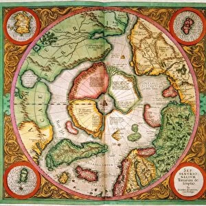
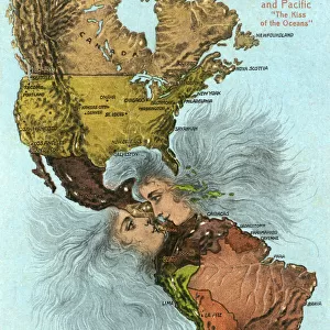
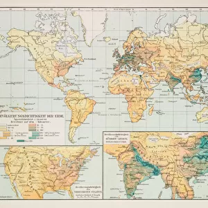
Western Hemisphere 1852 Map

![]()
Wall Art and Photo Gifts from Fine Art Storehouse
Western Hemisphere 1852 Map
Unleash your creativity and transform your space into a visual masterpiece!
benoitb
Media ID 13666935
© benoitb
Atlantic Ocean Color Swatch Geographic Map Line Art North America North Pole Pacific Ocean Sketch South America South Pole State The Americas Us State Border Western Hemisphere Classical Style Drawing Art Product Painted Image Retro Styled Victorian Style
FEATURES IN THESE COLLECTIONS
> Arts
> Landscape paintings
> Waterfall and river artworks
> River artworks
> Fine Art Storehouse
> Map
> Historical Maps
> Fine Art Storehouse
> Map
> USA Maps
> Maps and Charts
> Early Maps
> North America
> United States of America
> Lakes
> Related Images
> North America
> United States of America
> Maps
> South America
> Related Images
EDITORS COMMENTS
This print takes us back in time to the 19th century with its retro-styled Western Hemisphere 1852 Map. With intricate details and a classical Victorian style, this painted image transports us to an era of exploration and discovery. The map showcases the vastness of the Americas, from North America all the way down to South America. The artist's skillful use of line art and engraving techniques brings this antique illustration to life. Every river, lake, state border, and geographic feature is meticulously depicted, providing a comprehensive view of the physical geography of the Western Hemisphere. As we gaze at this color-swathed masterpiece, our eyes are drawn towards both poles - the North Pole and South Pole - reminding us of their significance in shaping our planet's history. The Atlantic Ocean stretches across one side while on the other lies the majestic Pacific Ocean. This drawing art product serves as a testament to human curiosity and ambition during that period. It allows us to appreciate how cartography played a crucial role in understanding our world centuries ago. Benoitb's print captures not only historical accuracy but also evokes a sense of wonderment for those who admire it today. Its vertical composition makes it an ideal centerpiece for any space seeking an infusion of old-world charm blended with artistic craftsmanship.
MADE IN THE USA
Safe Shipping with 30 Day Money Back Guarantee
FREE PERSONALISATION*
We are proud to offer a range of customisation features including Personalised Captions, Color Filters and Picture Zoom Tools
SECURE PAYMENTS
We happily accept a wide range of payment options so you can pay for the things you need in the way that is most convenient for you
* Options may vary by product and licensing agreement. Zoomed Pictures can be adjusted in the Cart.