Home > Aerial Photography > Related Images
Omaha Nebraska US City Street Map

![]()
Wall Art and Photo Gifts from Fine Art Storehouse
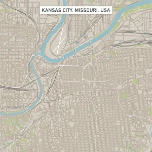
Omaha Nebraska US City Street Map
Vector Illustration of a City Street Map of Omaha, Nebraska, USA. Scale 1:60, 000.
All source data is in the public domain.
U.S. Geological Survey, US Topo
Used Layers:
USGS The National Map: National Hydrography Dataset (NHD)
USGS The National Map: National Transportation Dataset (NTD)
Unleash your creativity and transform your space into a visual masterpiece!
Frank Ramspott
Media ID 15192908
© Frank Ramspott, all rights reserved
Aerial View City Map Computer Graphic Directly Above Downtown District Gray Nebraska Road Map Text Digitally Generated Image Green Color Omaha White Color
FEATURES IN THESE COLLECTIONS
> Aerial Photography
> Related Images
> Animals
> Insects
> Hemiptera
> Green Scale
> Arts
> Contemporary art
> Digital artwork
> Street art
> Arts
> Landscape paintings
> Waterfall and river artworks
> River artworks
> Arts
> Portraits
> Pop art gallery
> Street art portraits
> Arts
> Street art graffiti
> Digital art
> Digital paintings
> Arts
> Street art graffiti
> Digital art
> Vector illustrations
> Fine Art Storehouse
> Map
> Street Maps
> Fine Art Storehouse
> Map
> USA Maps
> Maps and Charts
> Geological Map
> Maps and Charts
> Related Images
> North America
> United States of America
> Lakes
> Related Images
EDITORS COMMENTS
This print showcases a meticulously detailed vector illustration of Omaha, Nebraska's city street map. With a scale of 1:60,000, every intricate aspect of the city's layout is beautifully captured in this artwork. The image encompasses the downtown district, highlighting its vibrant streets and bustling atmosphere. The artist skillfully utilized various layers from reliable sources such as the U. S. Geological Survey and US Topo to create this stunning piece. The National Hydrography Dataset (NHD) layer accurately portrays the lake and river that grace Omaha's landscape, while the National Transportation Dataset (NTD) layer captures the extensive road network that connects this thriving city. Rendered in shades of gray, blue, white, and green colors against a backdrop of textural details, this digitally generated image offers an aerial view directly above Omaha. Its design seamlessly blends cartography with computer graphics to present an artistic representation of physical geography. With no people depicted within the frame, attention is solely focused on appreciating the intricacies of Omaha's urban fabric. This visually striking print by Frank Ramspott serves as both a decorative piece for any space and an informative tool for those interested in exploring or studying Omaha's unique cityscape
MADE IN THE USA
Safe Shipping with 30 Day Money Back Guarantee
FREE PERSONALISATION*
We are proud to offer a range of customisation features including Personalised Captions, Color Filters and Picture Zoom Tools
SECURE PAYMENTS
We happily accept a wide range of payment options so you can pay for the things you need in the way that is most convenient for you
* Options may vary by product and licensing agreement. Zoomed Pictures can be adjusted in the Cart.