Home > Arts > Street art graffiti > Digital art > Vector illustrations
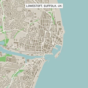
Moreno Valley California US City Street Map

![]()
Wall Art and Photo Gifts from Fine Art Storehouse
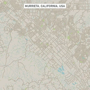
Moreno Valley California US City Street Map
Vector Illustration of a City Street Map of Moreno Valley, California, USA. Scale 1:60, 000.
All source data is in the public domain.
U.S. Geological Survey, US Topo
Used Layers:
USGS The National Map: National Hydrography Dataset (NHD)
USGS The National Map: National Transportation Dataset (NTD)
Unleash your creativity and transform your space into a visual masterpiece!
Frank Ramspott
Media ID 15055115
© Frank Ramspott, all rights reserved
Aerial View California City Map Computer Graphic Directly Above Downtown District Gray Road Map Text Digitally Generated Image Green Color White Color
FEATURES IN THESE COLLECTIONS
> Aerial Photography
> Related Images
> Animals
> Insects
> Hemiptera
> Green Scale
> Animals
> Mammals
> Cricetidae
> California Mouse
> Arts
> Contemporary art
> Digital artwork
> Street art
> Arts
> Landscape paintings
> Waterfall and river artworks
> River artworks
> Arts
> Portraits
> Pop art gallery
> Street art portraits
> Arts
> Street art graffiti
> Digital art
> Digital paintings
> Arts
> Street art graffiti
> Digital art
> Vector illustrations
> Fine Art Storehouse
> Map
> Street Maps
> Fine Art Storehouse
> Map
> USA Maps
> Maps and Charts
> Geological Map
> Maps and Charts
> Related Images
EDITORS COMMENTS
This print showcases a detailed and vibrant city street map of Moreno Valley, California, USA. With a scale of 1:60,000, this vector illustration provides an accurate representation of the city's layout. The image is digitally generated with no people present, allowing viewers to focus solely on the intricate cartography. The map incorporates various layers sourced from public domain data including USGS The National Map: National Hydrography Dataset (NHD) and USGS The National Map: National Transportation Dataset (NTD). These layers contribute to the comprehensive depiction of the city's hydrography and transportation networks. From its downtown district to the meandering river and serene lake, every element is meticulously portrayed in this visually striking composition. Aerially viewed from directly above, the image highlights Moreno Valley's physical geography with text labels in gray, green, blue, and white colors enhancing clarity. Created by talented artist Frank Ramspott for Fine Art Storehouse, this print seamlessly combines design aesthetics with geographical accuracy. It serves as both an informative tool for navigation enthusiasts and a visually appealing piece that adds sophistication to any space.
MADE IN THE USA
Safe Shipping with 30 Day Money Back Guarantee
FREE PERSONALISATION*
We are proud to offer a range of customisation features including Personalised Captions, Color Filters and Picture Zoom Tools
SECURE PAYMENTS
We happily accept a wide range of payment options so you can pay for the things you need in the way that is most convenient for you
* Options may vary by product and licensing agreement. Zoomed Pictures can be adjusted in the Cart.