Home > Aerial Photography > Related Images
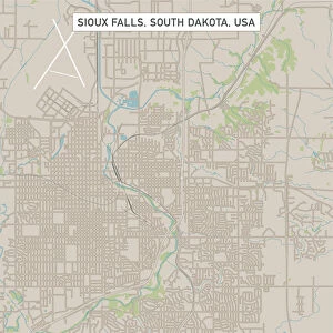
Columbia Missouri US City Street Map

![]()
Wall Art and Photo Gifts from Fine Art Storehouse
Columbia Missouri US City Street Map
Vector Illustration of a City Street Map of Columbia, Missouri, USA. Scale 1:60, 000.
All source data is in the public domain.
U.S. Geological Survey, US Topo
Used Layers:
USGS The National Map: National Hydrography Dataset (NHD)
USGS The National Map: National Transportation Dataset (NTD)
Unleash your creativity and transform your space into a visual masterpiece!
Frank Ramspott
Media ID 15215792
© Frank Ramspott, all rights reserved
Aerial View City Map Columbia Computer Graphic Directly Above Downtown District Gray Missouri Road Map Text Digitally Generated Image Green Color White Color
FEATURES IN THESE COLLECTIONS
> Aerial Photography
> Related Images
> Animals
> Insects
> Hemiptera
> Green Scale
> Arts
> Contemporary art
> Digital artwork
> Street art
> Arts
> Landscape paintings
> Waterfall and river artworks
> River artworks
> Arts
> Portraits
> Pop art gallery
> Street art portraits
> Arts
> Street art graffiti
> Digital art
> Digital paintings
> Arts
> Street art graffiti
> Digital art
> Vector illustrations
> Fine Art Storehouse
> Map
> Street Maps
> Fine Art Storehouse
> Map
> USA Maps
> Maps and Charts
> Geological Map
> Maps and Charts
> Related Images
> North America
> United States of America
> Lakes
> Related Images
EDITORS COMMENTS
This print showcases the intricate details of Columbia, Missouri's city street map. With a scale of 1:60,000, every road and landmark is meticulously illustrated in this vector illustration. The artist, Frank Ramspott, has skillfully utilized various layers from public domain sources such as the U. S. Geological Survey and US Topo to create this visually stunning piece. The downtown district comes alive with vibrant colors that highlight the bustling streets and architectural wonders. A serene lake and river gracefully flow through the heart of the city, adding a touch of tranquility amidst the urban landscape. From above, one can appreciate the seamless integration of roads and pathways that connect different neighborhoods within Columbia. This digitally generated image not only serves as an exquisite example of cartography but also celebrates the beauty of Columbia's physical geography. The combination of gray, blue, white, and green hues creates a harmonious palette that complements both natural elements and man-made structures. With no people present in this artwork, it allows viewers to focus solely on exploring each corner of Columbia without any distractions. Whether you are a resident or simply fascinated by maps and design, this print will undoubtedly captivate your imagination with its attention to detail and artistic flair.
MADE IN THE USA
Safe Shipping with 30 Day Money Back Guarantee
FREE PERSONALISATION*
We are proud to offer a range of customisation features including Personalised Captions, Color Filters and Picture Zoom Tools
SECURE PAYMENTS
We happily accept a wide range of payment options so you can pay for the things you need in the way that is most convenient for you
* Options may vary by product and licensing agreement. Zoomed Pictures can be adjusted in the Cart.