Home > Animals > Insects > Hemiptera > Green Scale
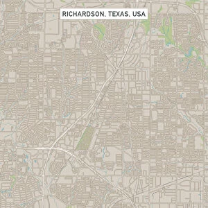
Anaheim California US City Street Map

![]()
Wall Art and Photo Gifts from Fine Art Storehouse
Anaheim California US City Street Map
Vector Illustration of a City Street Map of Anaheim, California, USA. Scale 1:60, 000.
All source data is in the public domain.
U.S. Geological Survey, US Topo
Used Layers:
USGS The National Map: National Hydrography Dataset (NHD)
USGS The National Map: National Transportation Dataset (NTD)
Unleash your creativity and transform your space into a visual masterpiece!
Frank Ramspott
Media ID 15055151
© Frank Ramspott, all rights reserved
Aerial View California City Map Computer Graphic Directly Above Downtown District Gray Road Map Text Digitally Generated Image Green Color White Color
FEATURES IN THESE COLLECTIONS
> Aerial Photography
> Related Images
> Animals
> Insects
> Hemiptera
> Green Scale
> Arts
> Landscape paintings
> Waterfall and river artworks
> River artworks
> Arts
> Portraits
> Pop art gallery
> Street art portraits
> Fine Art Storehouse
> Map
> Street Maps
> Fine Art Storehouse
> Map
> USA Maps
> Maps and Charts
> Geological Map
> North America
> United States of America
> California
> Related Images
> North America
> United States of America
> Lakes
> Related Images
> North America
> United States of America
> Maps
EDITORS COMMENTS
This print showcases a meticulously detailed city street map of Anaheim, California, USA. With a scale of 1:60,000, every intricate aspect of the city's layout is beautifully illustrated in this vector illustration. The source data used for this artwork is in the public domain and has been derived from reliable sources such as the U. S. Geological Survey and US Topo. The map incorporates various layers to provide comprehensive information about Anaheim's geography. It includes features like the Santa Ana River, downtown district, streets, roads, lakes, and more. The design is digitally generated with vibrant colors that bring life to the image. Captured from an aerial view directly above the cityscape, this visually stunning piece offers a unique perspective on Anaheim's urban landscape. The combination of gray text against a backdrop of green parks and blue water bodies creates an aesthetically pleasing contrast. Perfect for enthusiasts of cartography or those seeking to adorn their walls with striking art pieces depicting cities they love or have visited; this print will undoubtedly be a conversation starter. Its clean lines and attention to detail make it suitable for any space while adding an element of sophistication. Frank Ramspott skillfully crafted this artwork exclusively for Fine Art Storehouse using advanced computer graphics techniques. This particular edition does not feature people but focuses solely on showcasing Anaheim's physical geography through its carefully curated elements.
MADE IN THE USA
Safe Shipping with 30 Day Money Back Guarantee
FREE PERSONALISATION*
We are proud to offer a range of customisation features including Personalised Captions, Color Filters and Picture Zoom Tools
SECURE PAYMENTS
We happily accept a wide range of payment options so you can pay for the things you need in the way that is most convenient for you
* Options may vary by product and licensing agreement. Zoomed Pictures can be adjusted in the Cart.