Home > North America > United States of America > Massachusetts > Worcester
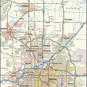
MA Worcester Hubbardston Vector Road Map

![]()
Wall Art and Photo Gifts from Fine Art Storehouse
MA Worcester Hubbardston Vector Road Map
MA Worcester Hubbardston Vector Road Map. All source data is in the public domain. U.S. Census Bureau Census Tiger. Used Layers: areawater, linearwater, roads, rails, cousub, pointlm, uac10
Unleash your creativity and transform your space into a visual masterpiece!
Frank Ramspott
Media ID 20692029
© Frank Ramspott, all rights reserved
City Map Computer Graphic County Digital Composite District Geographical Border Massachusetts Road Map Text Vector Worcester Digitally Generated Image Mount Pleasant
FEATURES IN THESE COLLECTIONS
> Animals
> Mammals
> Cats (Wild)
> Tiger
> Animals
> Mammals
> Muridae
> Water Mouse
> Arts
> Contemporary art
> Digital artwork
> Street art
> Arts
> Landscape paintings
> Waterfall and river artworks
> River artworks
> Arts
> Portraits
> Pop art gallery
> Street art portraits
> Arts
> Street art graffiti
> Digital art
> Digital paintings
> Fine Art Storehouse
> Map
> Reference Maps
> Maps and Charts
> Related Images
> North America
> United States of America
> Massachusetts
> Worcester
> Popular Themes
> Lake District
EDITORS COMMENTS
This vibrant and detailed print showcases the MA Worcester Hubbardston Vector Road Map, a stunning piece of cartography created by Frank Ramspott. The map encompasses various layers of information sourced from the U. S. Census Bureau Census Tiger, all of which are in the public domain. In this digitally generated image, we see a colorful and visually appealing representation of Massachusetts' Worcester County district. The design is meticulously crafted, highlighting geographical borders, cities, roads, rivers, lakes, and other significant features that define this area's physical geography. The absence of people in this composition allows us to focus solely on the intricate details presented before us. Every street name and landmark is clearly labeled with text that aids navigation through this expansive region. From Williamsville to Pitcherville and Barre Falls to Princeton Station - each locality is accurately depicted. Through computer graphics and digital compositing techniques employed by Ramspott, he has successfully transformed raw data into an aesthetically pleasing work of art. This vector-based image ensures high-quality resolution for any purpose it may serve. As we admire this print without mentioning its commercial use potentialities (as specified), we can appreciate how it seamlessly combines technology with traditional cartographic principles to create a visually striking representation of MA Worcester Hubbardston's road network and surrounding areas.
MADE IN THE USA
Safe Shipping with 30 Day Money Back Guarantee
FREE PERSONALISATION*
We are proud to offer a range of customisation features including Personalised Captions, Color Filters and Picture Zoom Tools
SECURE PAYMENTS
We happily accept a wide range of payment options so you can pay for the things you need in the way that is most convenient for you
* Options may vary by product and licensing agreement. Zoomed Pictures can be adjusted in the Cart.