Home > Arts > Contemporary art > Digital artwork > Street art
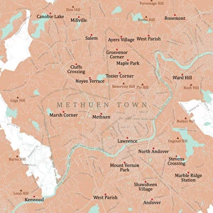
MA Essex Haverhill Vector Road Map

![]()
Wall Art and Photo Gifts from Fine Art Storehouse
MA Essex Haverhill Vector Road Map
MA Essex Haverhill Vector Road Map. All source data is in the public domain. U.S. Census Bureau Census Tiger. Used Layers: areawater, linearwater, roads, rails, cousub, pointlm, uac10
Unleash your creativity and transform your space into a visual masterpiece!
Frank Ramspott
Media ID 20689559
© Frank Ramspott, all rights reserved
Bradford City Map Computer Graphic County Digital Composite District Essex Geographical Border Highlands Massachusetts Road Map Text Vector Atkinson Digitally Generated Image Haverhill Merrimac Plaistow Westville
FEATURES IN THESE COLLECTIONS
> Animals
> Mammals
> Cats (Wild)
> Tiger
> Animals
> Mammals
> Muridae
> Water Mouse
> Arts
> Contemporary art
> Digital artwork
> Street art
> Arts
> Landscape paintings
> Waterfall and river artworks
> River artworks
> Arts
> Portraits
> Pop art gallery
> Street art portraits
> Arts
> Street art graffiti
> Digital art
> Digital paintings
> Europe
> United Kingdom
> England
> Essex
> Related Images
> Europe
> United Kingdom
> Scotland
> Highlands
> Related Images
> Fine Art Storehouse
> Map
> Reference Maps
> Maps and Charts
> Related Images
> Popular Themes
> Lake District
EDITORS COMMENTS
This print showcases the intricate details of the MA Essex Haverhill Vector Road Map. With its vibrant colors and precise cartography, this digitally generated image is a testament to the artistry of map design. The absence of people allows us to focus solely on the beauty and complexity of this visually stunning composition. The map encompasses various geographical features, including rivers, lakes, and towns such as Essex, Haverhill, Ward Hill, Bradford, Rosemont, Ayers Village, Westville, Plaistow, Merrimac, Highlands, and Atkinson. Each element has been meticulously rendered using layers sourced from U. S. Census Bureau Census Tiger data in the public domain. As we explore this city map's winding streets and thoroughfares depicted with remarkable precision and clarity; it becomes evident that every road leads to a new adventure waiting to be discovered. This digital composite seamlessly combines physical geography with computer graphics to create an immersive experience for any viewer. Frank Ramspott's masterful creation serves as both an informative tool for navigation enthusiasts and a work of art that celebrates our interconnected world. Whether displayed in a home or office setting or used for educational purposes; this striking vector road map print is sure to captivate all who lay eyes upon it.
MADE IN THE USA
Safe Shipping with 30 Day Money Back Guarantee
FREE PERSONALISATION*
We are proud to offer a range of customisation features including Personalised Captions, Color Filters and Picture Zoom Tools
SECURE PAYMENTS
We happily accept a wide range of payment options so you can pay for the things you need in the way that is most convenient for you
* Options may vary by product and licensing agreement. Zoomed Pictures can be adjusted in the Cart.