Home > Europe > United Kingdom > England > Bristol > Bristol
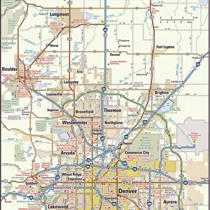
MA Bristol Acushnet Vector Road Map

![]()
Wall Art and Photo Gifts from Fine Art Storehouse
MA Bristol Acushnet Vector Road Map
MA Bristol Acushnet Vector Road Map. All source data is in the public domain. U.S. Census Bureau Census Tiger. Used Layers: areawater, linearwater, roads, rails, cousub, pointlm, uac10
Unleash your creativity and transform your space into a visual masterpiece!
Frank Ramspott
Media ID 20689025
© Frank Ramspott, all rights reserved
Bristol City Map Computer Graphic County Digital Composite District Geographical Border Massachusetts Oxford Road Map Text Vector Clifford Digitally Generated Image
FEATURES IN THESE COLLECTIONS
> Animals
> Mammals
> Cats (Wild)
> Tiger
> Animals
> Mammals
> Muridae
> Plains Mouse
> Animals
> Mammals
> Muridae
> Water Mouse
> Arts
> Contemporary art
> Digital artwork
> Street art
> Arts
> Landscape paintings
> Waterfall and river artworks
> River artworks
> Arts
> Portraits
> Pop art gallery
> Street art portraits
> Arts
> Street art graffiti
> Digital art
> Digital paintings
> Europe
> United Kingdom
> England
> Bristol
> Bristol
> Fine Art Storehouse
> Map
> Reference Maps
> Maps and Charts
> Related Images
EDITORS COMMENTS
This vibrant and detailed print showcases the MA Bristol Acushnet Vector Road Map, a stunning piece of cartography created by Frank Ramspott. With all source data obtained from the public domain, this map is an accurate representation of the area's physical geography. The digital composite design features various layers including areawater, linearwater, roads, rails, cousub, pointlm, and uac10. Every element has been meticulously crafted to provide a comprehensive overview of Massachusetts' Bristol County district. In this color image captured through computer graphics, geographical borders are clearly defined while cities and towns stand out with their distinct typography. The road map highlights major streets and highways connecting different areas within the county. Notably featured in this artwork are prominent landmarks such as Coury Heights, Long Plain, Pine Hill Acres, Tinkhamtown, Wolf Lake, Snipatuit Pond, Clifford Park Westgate Park, and Oxford. These locations add depth and character to the overall composition. Perfect for enthusiasts of cartography or those seeking a visually appealing representation of Bristol County's topography without any commercial use intentions in mind; this digitally generated image will surely captivate viewers. Whether displayed at home or in an office setting; its intricate details make it both aesthetically pleasing and informative.
MADE IN THE USA
Safe Shipping with 30 Day Money Back Guarantee
FREE PERSONALISATION*
We are proud to offer a range of customisation features including Personalised Captions, Color Filters and Picture Zoom Tools
SECURE PAYMENTS
We happily accept a wide range of payment options so you can pay for the things you need in the way that is most convenient for you
* Options may vary by product and licensing agreement. Zoomed Pictures can be adjusted in the Cart.