Home > Arts > Contemporary art > Digital artwork > Street art
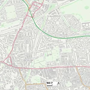
CT Litchfield North Canaan Vector Road Map

![]()
Wall Art and Photo Gifts from Fine Art Storehouse
CT Litchfield North Canaan Vector Road Map
CT Litchfield North Canaan Vector Road Map. All source data is in the public domain. U.S. Census Bureau Census Tiger. Used Layers: areawater, linearwater, roads, rails, cousub, pointlm, uac10
Unleash your creativity and transform your space into a visual masterpiece!
Frank Ramspott
Media ID 20687711
© Frank Ramspott, all rights reserved
Canaan Canaan Valley City Map Computer Graphic Connecticut County Digital Composite District Geographical Border Litchfield Road Map Text Vector Village Clayton Digitally Generated Image Gomorrah Pine Grove Sodom
FEATURES IN THESE COLLECTIONS
> Animals
> Mammals
> Cats (Wild)
> Tiger
> Animals
> Mammals
> Muridae
> Water Mouse
> Arts
> Contemporary art
> Digital artwork
> Street art
> Arts
> Landscape paintings
> Waterfall and river artworks
> River artworks
> Arts
> Portraits
> Pop art gallery
> Street art portraits
> Arts
> Street art graffiti
> Digital art
> Digital paintings
> Fine Art Storehouse
> Map
> Reference Maps
> Maps and Charts
> Related Images
> Popular Themes
> Lake District
EDITORS COMMENTS
This print showcases the intricate details of the CT Litchfield North Canaan Vector Road Map. Designed by Frank Ramspott, this digitally generated image is a testament to his exceptional cartography skills. The map encompasses various layers such as roads, rails, water bodies, and geographical borders sourced from the U. S. Census Bureau Census Tiger data. In vibrant colors and precise vector graphics, this visually appealing composition brings to life the physical geography of Connecticut's Litchfield County. With no people in sight, it solely focuses on highlighting the region's cities, towns, villages, and their interconnected streets. The inclusion of text enhances its functionality as a road map while also adding an artistic touch to the overall design. Rivers and lakes gracefully meander through the landscape, providing both aesthetic beauty and practical navigation references. Noteworthy locations like Sodom, Gomorrah, Clayton, Ashley Falls are meticulously marked alongside natural landmarks such as Canaan Valley or Bradford Mountain. This comprehensive representation ensures that anyone exploring these areas can easily navigate their way around. Perfect for enthusiasts of cartography or those with a deep appreciation for digital composites and computer graphics; this print is a striking addition to any art collection. It serves as a reminder that even in our technologically advanced world; there is still immense value in preserving traditional forms of mapping for both functional and aesthetic purposes.
MADE IN THE USA
Safe Shipping with 30 Day Money Back Guarantee
FREE PERSONALISATION*
We are proud to offer a range of customisation features including Personalised Captions, Color Filters and Picture Zoom Tools
SECURE PAYMENTS
We happily accept a wide range of payment options so you can pay for the things you need in the way that is most convenient for you
* Options may vary by product and licensing agreement. Zoomed Pictures can be adjusted in the Cart.