Home > North America > United States of America > Connecticut > Hartford
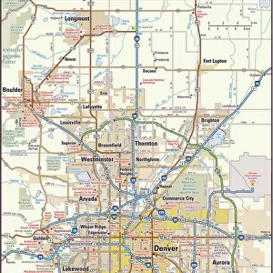
CT Hartford Bloomfield Vector Road Map

![]()
Wall Art and Photo Gifts from Fine Art Storehouse
CT Hartford Bloomfield Vector Road Map
CT Hartford Bloomfield Vector Road Map. All source data is in the public domain. U.S. Census Bureau Census Tiger. Used Layers: areawater, linearwater, roads, rails, cousub, pointlm, uac10
Unleash your creativity and transform your space into a visual masterpiece!
Frank Ramspott
Media ID 20688131
© Frank Ramspott, all rights reserved
City Map Computer Graphic Connecticut County Digital Composite District Geographical Border Hartford Road Map Text Vector Birchwood Bloomfield Bluehill Cottage Grove Digitally Generated Image Wilson
FEATURES IN THESE COLLECTIONS
> Animals
> Mammals
> Cats (Wild)
> Tiger
> Animals
> Mammals
> Muridae
> Water Mouse
> Arts
> Artists
> W
> Wilson Wilson
> Arts
> Contemporary art
> Digital artwork
> Street art
> Arts
> Landscape paintings
> Waterfall and river artworks
> River artworks
> Arts
> Portraits
> Pop art gallery
> Street art portraits
> Arts
> Street art graffiti
> Digital art
> Digital paintings
> Fine Art Storehouse
> Map
> Reference Maps
> Maps and Charts
> Related Images
> North America
> United States of America
> Connecticut
> Hartford
> Popular Themes
> Lake District
EDITORS COMMENTS
This print showcases the intricate and detailed CT Hartford Bloomfield Vector Road Map. Designed by Frank Ramspott, this digitally generated image is a testament to the art of cartography. With no people in sight, the focus lies solely on the vibrant colors and precise lines that bring this map to life. Utilizing public domain data from the U. S. Census Bureau Census Tiger, Ramspott has expertly layered various elements such as roads, rails, water bodies, and geographical borders to create a comprehensive representation of Connecticut's capital city and its surrounding areas. From bustling cities like Hartford to charming towns like Bloomfield, every location is clearly labeled with legible text. The inclusion of natural features like rivers and lakes adds depth to this visually striking composition. One can't help but be drawn into exploring each neighborhood depicted - from King Phillip Mountain to Birchwood; from Poquonock to Spoonville; from Tariffville to Cottage Grove; and beyond. With its computer-generated graphics and digital compositing techniques, this artwork seamlessly combines aesthetics with functionality. Whether you're a resident or visitor, this CT Hartford Bloomfield Vector Road Map print will surely enhance your understanding of the region's physical geography while adding an artistic touch to any space it graces.
MADE IN THE USA
Safe Shipping with 30 Day Money Back Guarantee
FREE PERSONALISATION*
We are proud to offer a range of customisation features including Personalised Captions, Color Filters and Picture Zoom Tools
SECURE PAYMENTS
We happily accept a wide range of payment options so you can pay for the things you need in the way that is most convenient for you
* Options may vary by product and licensing agreement. Zoomed Pictures can be adjusted in the Cart.