Home > North America > Greenland > Maps
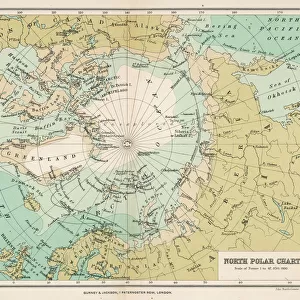
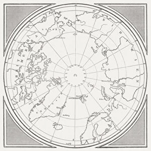
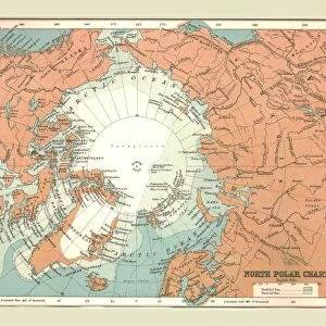
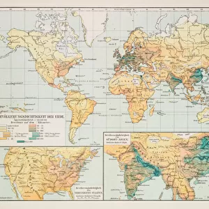
North Polar Chart 1895

![]()
Wall Art and Photo Gifts from Fine Art Storehouse
North Polar Chart 1895
Meyers Konversations-Lexikon
Unleash your creativity and transform your space into a visual masterpiece!
THEPALMER
Media ID 15241461
© Roberto A Sanchez
Arctic Atlas Chart Dome Earth Greenland Hemisphere North Pole Polar Climate World Map Obsolete Retro Styled
FEATURES IN THESE COLLECTIONS
> Fine Art Storehouse
> Map
> Historical Maps
> Maps and Charts
> Early Maps
> Maps and Charts
> World
> North America
> Greenland
> Maps
EDITORS COMMENTS
This print takes us back in time to the year 1895, showcasing a North Polar Chart from the renowned Meyers Konversations-Lexikon. With its retro-styled design and antique charm, this piece of cartography transports us to an era when hand-drawn maps were meticulously engraved onto paper. The intricate details of this engraving depict the physical geography of the Arctic region, offering a glimpse into a world that has long since evolved. The chart showcases Greenland, known for its polar climate and vast icy landscapes, while also encompassing other parts of the Northern Hemisphere. The dome-like shape adds depth and dimension to this vintage map, reminding us of Earth's spherical nature. As we admire this obsolete yet timeless work of art, we are reminded of how far our understanding of the world has come since 1895. This print serves as a testament to human curiosity and exploration throughout history. It invites us to reflect on our ever-changing relationship with our planet and appreciate the advancements made in modern cartography. "The North Polar Chart 1895" by THEPALMER is not just an image; it is a window into both past knowledge and future possibilities. Its presence evokes nostalgia for simpler times while igniting curiosity about what lies beyond our current understanding. Whether displayed in homes or offices, this unique piece will undoubtedly spark conversations about history, geography, and mankind's unending quest for discovery.
MADE IN THE USA
Safe Shipping with 30 Day Money Back Guarantee
FREE PERSONALISATION*
We are proud to offer a range of customisation features including Personalised Captions, Color Filters and Picture Zoom Tools
SECURE PAYMENTS
We happily accept a wide range of payment options so you can pay for the things you need in the way that is most convenient for you
* Options may vary by product and licensing agreement. Zoomed Pictures can be adjusted in the Cart.