Home > North America > United States of America > New York > New York > Maps
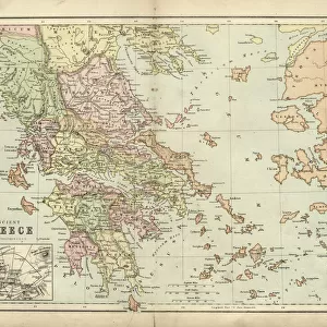
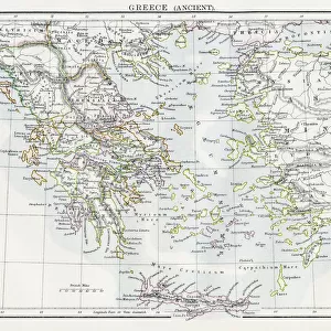
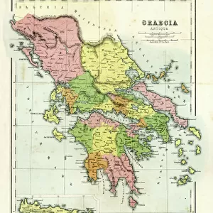
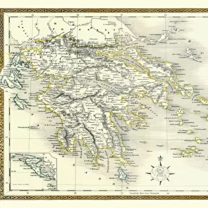
Antique Greece empire map 1895

![]()
Wall Art and Photo Gifts from Fine Art Storehouse
Antique Greece empire map 1895
Encyclopedia Britannica 9th Edition Vol I New York, Samuel Hall 1878
Unleash your creativity and transform your space into a visual masterpiece!
THEPALMER
Media ID 13609241
© This content is subject to copyright
Classical Greek Empire Greece Hellenic
FEATURES IN THESE COLLECTIONS
> Europe
> Greece
> Related Images
> Europe
> Related Images
> Fine Art Storehouse
> Map
> Historical Maps
> Historic
> Ancient civilizations
> Ancient Greece
> Greek history
> Maps and Charts
> Related Images
> North America
> United States of America
> Maps
> North America
> United States of America
> New York
> New York
> Maps
> North America
> United States of America
> New York
> Related Images
EDITORS COMMENTS
This print showcases an exquisite piece of history, the "Antique Greece empire map 1895". Taken from the Encyclopedia Britannica 9th Edition Vol I, published in New York by Samuel Hall in 1878, this remarkable lithograph offers a glimpse into the classical world of ancient Greece. With its horizontal orientation and intricate details, it transports us back to a time when cartography was both an art form and a scientific endeavor. The engraving and etching techniques employed in creating this map highlight the craftsmanship of yesteryears. Every line meticulously drawn on this old antique map tells a story of exploration and discovery. It captures not only the physical geography but also the grandeur of one of history's most influential empires. As we delve into this illustration, we are reminded of Greece's rich Hellenic heritage that has shaped Western civilization for centuries. The map serves as a visual testament to their vast empire that once spanned across Europe and beyond. "The Antique Greece empire map 1895" is more than just a decorative piece; it is an invitation to explore our past and appreciate the brilliance of those who came before us. Its presence adds depth and character to any space while igniting curiosity about our collective human journey. Authored by THEPALMER, this print from Fine Art Storehouse allows us to bring home a slice of history – an enduring reminder that even within today's fast-paced world, there is always room for appreciation for antiquity's timeless beauty
MADE IN THE USA
Safe Shipping with 30 Day Money Back Guarantee
FREE PERSONALISATION*
We are proud to offer a range of customisation features including Personalised Captions, Color Filters and Picture Zoom Tools
SECURE PAYMENTS
We happily accept a wide range of payment options so you can pay for the things you need in the way that is most convenient for you
* Options may vary by product and licensing agreement. Zoomed Pictures can be adjusted in the Cart.