Home > Europe > Italy > Veneto > Venice
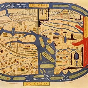
World map of Claudius Ptolemaeus (Claude Ptolemee, 90-168 ap JC)
")
![]()
Wall Art and Photo Gifts from Fine Art Finder
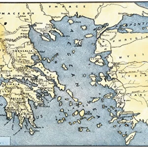
World map of Claudius Ptolemaeus (Claude Ptolemee, 90-168 ap JC)
LRI4648449 World map of Claudius Ptolemaeus (Claude Ptolemee, 90-168 ap JC), Greek astronomer and astrologer - Representation of the Flat Earth without the North and South Poles and without the American Contains - 15th century Manuscript - Venice, Biblioteca Marciana by Unknown Artist, (15th century); Biblioteca Nazionale Marciana, Venice, Italy; (add.info.: World map of Claudius Ptolemaeus (Claude Ptolemee, 90-168 ap JC), Greek astronomer and astrologer - Representation of the Flat Earth without the North and South Poles and without the American Contains - 15th century Manuscript - Venice, Biblioteca Marciana); Luisa Ricciarini; out of copyright
Media ID 23015678
© Luisa Ricciarini / Bridgeman Images
2 2nd 2nd 2nd Ii Iird Century Claude 90 168 Planisphere Ptolemy Asian Asian Geographical Map
FEATURES IN THESE COLLECTIONS
> Africa
> Related Images
> Africa
> South Africa
> Maps
> Africa
> South Africa
> Related Images
> Europe
> Greece
> Related Images
> Europe
> Italy
> Veneto
> Venice
> Fine Art Finder
> Artists
> Unknown Artist
> Historic
> Ancient civilizations
> Ancient Greece
> Greek history
EDITORS COMMENTS
This print showcases the world map of Claudius Ptolemaeus, a renowned Greek astronomer and astrologer from the 2nd century. The intricate manuscript, dating back to the 15th century, is housed in the Biblioteca Marciana in Venice, Italy. The map offers a unique perspective of the Earth as it was understood during Ptolemy's time. It represents a flat Earth without the North and South Poles and excludes any mention of America. This fascinating depiction provides insight into ancient geographical knowledge and highlights how our understanding of the world has evolved over time. The unknown artist behind this masterpiece skillfully illuminates each continent with delicate details, capturing both European and African regions with precision. The planisphere reveals an amalgamation of cultures and civilizations that existed during Ptolemy's era. Luisa Ricciarini expertly captures this historical artifact through her lens, allowing viewers to appreciate its beauty while contemplating humanity's progress in cartography. As we gaze upon this mesmerizing artwork, we are reminded of how far we have come in unraveling the mysteries of our planet. This photograph serves as a testament to human curiosity and our relentless pursuit of knowledge throughout history. It invites us to explore not only physical landscapes but also intellectual landscapes that shape our understanding of ourselves and the world around us.
MADE IN THE USA
Safe Shipping with 30 Day Money Back Guarantee
FREE PERSONALISATION*
We are proud to offer a range of customisation features including Personalised Captions, Color Filters and Picture Zoom Tools
SECURE PAYMENTS
We happily accept a wide range of payment options so you can pay for the things you need in the way that is most convenient for you
* Options may vary by product and licensing agreement. Zoomed Pictures can be adjusted in the Cart.