Home > Europe > France > Paris > Maps
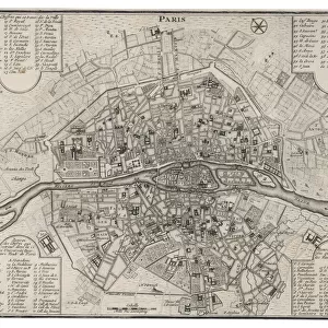
Street Map of Paris, 1890, France, Historic, digitally restored reproduction of an original 19th century original, Europe

![]()
Wall Art and Photo Gifts from Fine Art Finder
Street Map of Paris, 1890, France, Historic, digitally restored reproduction of an original 19th century original, Europe
7279590 Street Map of Paris, 1890, France, Historic, digitally restored reproduction of an original 19th century original, Europe by Unknown Artist, (19th century); Private Collection; (add.info.: Street Map of Paris, 1890, France, Historic, digitally restored reproduction of an original 19th century original, Europe); © Imagebroker
Media ID 28003598
© Imagebroker / Bridgeman Images
FEATURES IN THESE COLLECTIONS
> Arts
> Contemporary art
> Digital artwork
> Street art
> Europe
> France
> Paris
> Maps
> Europe
> France
> Paris
> Related Images
> Fine Art Finder
> Artists
> Unknown Artist
> Maps and Charts
> Early Maps
> Maps and Charts
> Related Images
EDITORS COMMENTS
This print showcases a meticulously restored reproduction of an original 19th-century street map of Paris, France. The map, dating back to 1890, offers a fascinating glimpse into the historic cityscape of one of Europe's most iconic capitals. The digitally enhanced restoration brings out the intricate details and vibrant colors that were present in the original artwork. Every street and landmark is beautifully depicted, allowing viewers to immerse themselves in the rich history and culture of Paris during this era. As you explore this exquisite piece, you can't help but be transported back in time to the bustling streets of late 19th-century Paris. The map serves as both a historical document and a work of art, capturing the essence of a bygone era. With its delicate cartography and vivid color palette, this print is not only visually stunning but also provides valuable insights into urban planning and architectural development during that period. It is truly a treasure for any lover of history or admirer of European cities. Whether displayed in your home or office space, this Street Map of Paris from 1890 will undoubtedly spark curiosity and conversation among all who lay eyes upon it. Step into the past with this remarkable reproduction brought to life by Sunny Celeste on behalf of Fine Art Finder.
MADE IN THE USA
Safe Shipping with 30 Day Money Back Guarantee
FREE PERSONALISATION*
We are proud to offer a range of customisation features including Personalised Captions, Color Filters and Picture Zoom Tools
SECURE PAYMENTS
We happily accept a wide range of payment options so you can pay for the things you need in the way that is most convenient for you
* Options may vary by product and licensing agreement. Zoomed Pictures can be adjusted in the Cart.