Home > Europe > France > Paris > Maps
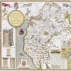
Map showing the world trade shipping routes, cartography by Pierre Duval (1619-83

![]()
Wall Art and Photo Gifts from Fine Art Finder
Map showing the world trade shipping routes, cartography by Pierre Duval (1619-83
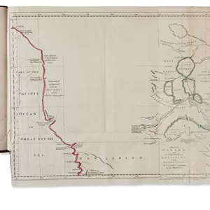
REV345800 Map showing the world trade shipping routes, cartography by Pierre Duval (1619-83) published in 1686, Paris (colour engraving) by French School, (17th century); Private Collection; (add.info.: la carte universelle pour le commerce; cartographie de Pierre du Val, geographe du Roi de France Louis XIV; geographer of King Louis XIV; routes pour la navigation des Indes occidentales et orientales ; ); French, out of copyright
Media ID 23376188
© Bridgeman Images
Commercial Company Continent Economics Geographical Mapping Ports Route Four Continents
FEATURES IN THESE COLLECTIONS
> Africa
> Related Images
> Asia
> Related Images
> Europe
> France
> Paris
> Maps
> Europe
> France
> Paris
> Related Images
> Fine Art Finder
> Artists
> French School
> Fine Art Finder
> Maps (celestial & Terrestrial)
> Maps and Charts
> Related Images
EDITORS COMMENTS
This print showcases a remarkable map created by Pierre Duval, a renowned French cartographer of the 17th century. Published in 1686 in Paris, this color engraving provides an invaluable insight into the world trade shipping routes during that era. Titled "Map showing the world trade shipping routes". Duval's masterpiece was aptly referred to as "la carte universelle pour le commerce" or "the universal map for commerce". As the official geographer of King Louis XIV of France, Duval meticulously charted out the navigation routes for both the East and West Indies, enabling seamless trading between continents. The intricately detailed map highlights various geographical features such as Asia, Africa, Europe, and America. It serves as a testament to the significant role played by these four continents in global economics and commercial activities at that time. With its depiction of numerous ports along these trade routes, this historic artifact offers valuable insights into how goods were transported across vast distances centuries ago. The exquisite engravings capture the essence of maritime industry and mapping techniques prevalent during Duval's time. Now preserved in a private collection, this extraordinary piece from Bridgeman Images allows us to marvel at not only Duval's skillful craftsmanship but also his contribution to our understanding of global trade history.
MADE IN THE USA
Safe Shipping with 30 Day Money Back Guarantee
FREE PERSONALISATION*
We are proud to offer a range of customisation features including Personalised Captions, Color Filters and Picture Zoom Tools
SECURE PAYMENTS
We happily accept a wide range of payment options so you can pay for the things you need in the way that is most convenient for you
* Options may vary by product and licensing agreement. Zoomed Pictures can be adjusted in the Cart.