Home > Arts > Artists > W > Frederick de Wit
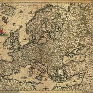
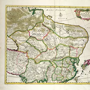
Map of Provence (France) (etching, 1671)
 (etching, 1671)")
![]()
Wall Art and Photo Gifts from Fine Art Finder
Map of Provence (France) (etching, 1671)
LRI4709837 Map of Provence (France) (etching, 1671) by Wit, Frederick de (1630-1706); Private Collection; (add.info.: Map of Provence (France) - Strong water extracted from " Theatrum Orbis", 1671, by Frederick De Wit (Frederico de Witt) (1630-1706)); Luisa Ricciarini; Dutch, out of copyright
Media ID 22464842
© Luisa Ricciarini / Bridgeman Images
Atlas Book Provence Riviera Geographical Map
FEATURES IN THESE COLLECTIONS
> Arts
> Artists
> W
> Frederick de Wit
> Fine Art Finder
> Artists
> Frederick de Wit
> Maps and Charts
> Related Images
EDITORS COMMENTS
This print showcases a historic map of Provence, France, created through the intricate art of etching in 1671 by Frederick de Wit. The map is a part of a private collection and offers viewers a glimpse into the geographical landscape of this picturesque region. With meticulous detail and precision, De Wit's craftsmanship brings to life the beauty and complexity of Provence. From its rolling hills to its charming villages, every corner is carefully depicted on this exquisite piece. This particular map was extracted from "Theatrum Orbis" a renowned atlas book that showcased maps from around the world. Luisa Ricciarini has skillfully captured this remarkable work with her camera lens, preserving it for generations to come. Through her lens, we are able to appreciate not only the artistry behind De Wit's etching but also gain insight into the historical significance of cartography during that era. As we gaze upon this print, we are transported back in time to 17th-century France when maps were essential tools for exploration and discovery. It serves as a reminder of how far we have come in our understanding of geography while also appreciating the enduring beauty found within these ancient works. This print by Luisa Ricciarini allows us to bring home a piece of history and marvel at both De Wit's talent as an artist and Ricciarini's ability to capture its essence through her photography skills.
MADE IN THE USA
Safe Shipping with 30 Day Money Back Guarantee
FREE PERSONALISATION*
We are proud to offer a range of customisation features including Personalised Captions, Color Filters and Picture Zoom Tools
SECURE PAYMENTS
We happily accept a wide range of payment options so you can pay for the things you need in the way that is most convenient for you
* Options may vary by product and licensing agreement. Zoomed Pictures can be adjusted in the Cart.