Home > Africa > South Africa > Maps
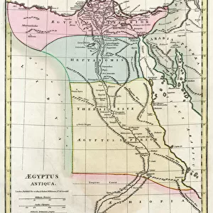
Section of a Map of South Africa, including Pitsani (whence Jameson started), Mafeking, Pretoria, and Johannesburg (engraving)
, Mafeking, Pretoria, and Johannesburg (engraving)")
![]()
Wall Art and Photo Gifts from Fine Art Finder
Section of a Map of South Africa, including Pitsani (whence Jameson started), Mafeking, Pretoria, and Johannesburg (engraving)
1605487 Section of a Map of South Africa, including Pitsani (whence Jameson started), Mafeking, Pretoria, and Johannesburg (engraving) by English School, (19th century); Private Collection; (add.info.: Section of a Map of South Africa, including Pitsani (whence Jameson started), Mafeking, Pretoria, and Johannesburg. Illustration for The Illustrated London News, 25 February 1896.
English School (19th Century)); Look and Learn / Illustrated Papers Collection
Media ID 22264676
© Look and Learn / Illustrated Papers Collection / Bridgeman Images
Jameson Jameson Raid Johannesburg Mafeking Pretoria Section Started
FEATURES IN THESE COLLECTIONS
> Africa
> Related Images
> Africa
> South Africa
> Johannesburg
> Africa
> South Africa
> Maps
> Africa
> South Africa
> Pretoria
> Africa
> South Africa
> Related Images
> Fine Art Finder
> Artists
> E. Jennings
> Fine Art Finder
> Artists
> English School
> Maps and Charts
> Related Images
EDITORS COMMENTS
This engraving takes us back to the 19th century, offering a glimpse into the intricate details of a section of a map of South Africa. The print showcases significant locations such as Pitsani, Mafeking, Pretoria, and Johannesburg - all key players in the historical events that unfolded during this time. The focal point of this artwork is undoubtedly Pitsani, from where Jameson embarked on his infamous raid. It was here that history was set in motion, forever changing the course of South African politics. As we trace our eyes across the map, we are transported through time to witness the interconnectedness between these influential cities. The precision and craftsmanship evident in this engraving highlight its importance as an educational tool for readers of The Illustrated London News in February 1896. Its purpose was not only to inform but also to ignite curiosity about distant lands and their political landscapes. As we study this piece closely, it becomes clear that each line represents more than just geographical boundaries; they symbolize power struggles and colonial ambitions. This print serves as a reminder of how maps have always played an integral role in shaping our understanding of nations and their histories. Preserved within private collections until now, this remarkable work allows us to appreciate both its artistic merit and historical significance. Through its detailed depiction of South Africa's landscape at a pivotal moment in time, it invites us to reflect upon the complex tapestry woven by past generations - one that continues to shape our present reality.
MADE IN THE USA
Safe Shipping with 30 Day Money Back Guarantee
FREE PERSONALISATION*
We are proud to offer a range of customisation features including Personalised Captions, Color Filters and Picture Zoom Tools
SECURE PAYMENTS
We happily accept a wide range of payment options so you can pay for the things you need in the way that is most convenient for you
* Options may vary by product and licensing agreement. Zoomed Pictures can be adjusted in the Cart.