Home > Europe > United Kingdom > Scotland > Strathclyde > Lanark
The Graphic Parliamentary Map (colour litho)
")
![]()
Wall Art and Photo Gifts from Fine Art Finder
The Graphic Parliamentary Map (colour litho)
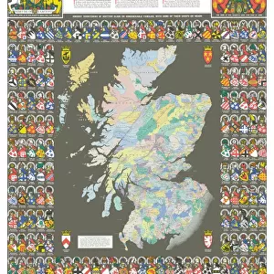
1047895 The Graphic Parliamentary Map (colour litho) by English School, (19th century); Private Collection; (add.info.: The Graphic Parliamentary Map, showing the Members returned for County Divisions and Boroughs. Illustration for The Graphic, 1892.); Look and Learn / Illustrated Papers Collection; English, out of copyright
Media ID 22651584
© Look and Learn / Illustrated Papers Collection / Bridgeman Images
Boroughs Durham Lanark Members Middlesex Renfrew Returned Showing South East Lancashire South West Staffordshire
FEATURES IN THESE COLLECTIONS
> Arts
> Artists
> D
> Alfred
> Related Images
> Europe
> Republic of Ireland
> Dublin
> Europe
> Republic of Ireland
> Maps
> Europe
> United Kingdom
> England
> Durham
> Durham
> Europe
> United Kingdom
> England
> Lancashire
> Related Images
> Europe
> United Kingdom
> England
> Middlesex
> Related Images
> Europe
> United Kingdom
> England
> Staffordshire
> Related Images
> Europe
> United Kingdom
> Scotland
> Maps
> Europe
> United Kingdom
> Scotland
> Strathclyde
> Lanark
> Fine Art Finder
> Artists
> Alfred Chantrey Corbould
> Fine Art Finder
> Artists
> English School
> Fine Art Finder
> Temp Classification
EDITORS COMMENTS
The Graphic Parliamentary Map: A Snapshot of Political Representation in 19th Century England". This print showcases "The Graphic Parliamentary Map" a remarkable colour lithograph created by an anonymous English artist in the 19th century. The map, now part of a private collection, offers a fascinating glimpse into the political landscape during the general election of 1892. With intricate detail and vibrant hues, this illustration depicts Members returned for County Divisions and Boroughs across Ireland, South West England, South East Lancashire, Dublin County, Staffordshire, Lanark in Scotland, Middlesex, Durham, and Renfrew. It provides viewers with an invaluable historical record of parliamentary representation at that time. As we explore this visual treasure trove further, we discover metropolitan boroughs and county divisions meticulously marked on the map. Each constituency is represented by its elected Member who played a crucial role in shaping legislation and policy decisions. This rare find from Look and Learn / Illustrated Papers Collection not only captures our attention but also transports us back to an era when politics was passionately debated within these hallowed halls. It serves as a reminder of how far democracy has come since then while acknowledging the enduring importance of representative governance. Bridgeman Images has preserved this piece to honor its artistic merit as well as its historical significance. Let us marvel at this snapshot frozen in time—a testament to both artistry and politics—inviting us to reflect on our own democratic journey.
MADE IN THE USA
Safe Shipping with 30 Day Money Back Guarantee
FREE PERSONALISATION*
We are proud to offer a range of customisation features including Personalised Captions, Color Filters and Picture Zoom Tools
SECURE PAYMENTS
We happily accept a wide range of payment options so you can pay for the things you need in the way that is most convenient for you
* Options may vary by product and licensing agreement. Zoomed Pictures can be adjusted in the Cart.