Home > Europe > France > Canton > Bas Rhin
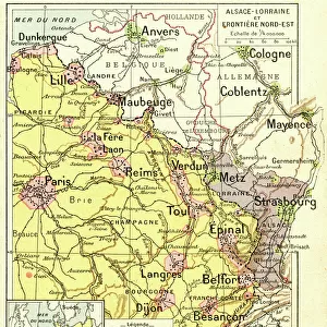
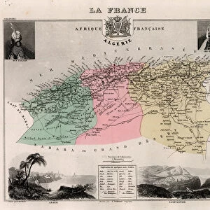
Bas Rhin (Bas-Rhin, 67), Alsace - La France et ses Colonies. Atlas illustrates one hundred and five maps from the maps of the depot of war, bridges and footwear and the Navy by M. VUILLEMIN. 1876
, Alsace - La France et ses Colonies. Atlas illustrates one hundred and five maps from the maps of the depot of war, bridges and footwear and the Navy by M. VUILLEMIN. 1876")
![]()
Wall Art and Photo Gifts from Fine Art Finder
Bas Rhin (Bas-Rhin, 67), Alsace - La France et ses Colonies. Atlas illustrates one hundred and five maps from the maps of the depot of war, bridges and footwear and the Navy by M. VUILLEMIN. 1876
XEE4144467 Bas Rhin (Bas-Rhin, 67), Alsace - La France et ses Colonies. Atlas illustrates one hundred and five maps from the maps of the depot of war, bridges and footwear and the Navy by M. VUILLEMIN. 1876. by Vuillemin, Alexandre (1812-1886); Private Collection; (add.info.: Bas Rhin (Bas-Rhin, 67), Alsace - La France et ses Colonies. Atlas illustrates one hundred and five maps from the maps of the depot of war, bridges and footwear and the Navy by M. VUILLEMIN. 1876.); Stefano Bianchetti; French, out of copyright
Media ID 25183038
© Stefano Bianchetti / Bridgeman Images
Alsace Alsace Lorraine Atlas Book Bas Rhine 67 Lorraine Geographical Map
FEATURES IN THESE COLLECTIONS
> Europe
> France
> Canton
> Bas Rhin
> Europe
> France
> Canton
> Rhin
> Fine Art Finder
> Artists
> Alexandre Vuillemin
> Maps and Charts
> Related Images
> Services
> Royal Navy
EDITORS COMMENTS
This print showcases a historical map titled "Bas Rhin (Bas-Rhin, 67), Alsace - La France et ses Colonies". Created in 1876 by Alexandre Vuillemin, this atlas features an impressive collection of one hundred and five maps from various sources such as the depot of war, bridges and footwear, and the Navy. The intricate details and precision of these maps provide a fascinating glimpse into the geography of Alsace-Lorraine during that time. The Bas Rhin region is highlighted in this particular map, offering a comprehensive view of its geographical features. From rivers to mountains, cities to villages, every aspect is meticulously depicted with vibrant colors. This piece serves as both an educational tool for understanding the landscape and as a work of art due to its aesthetic appeal. Stefano Bianchetti has skillfully captured this engraving photographically, preserving its historical significance for future generations. The fine detailing and vivid colors bring life to each element on the map while maintaining its vintage charm. As we gaze upon this remarkable artwork, we are transported back in time to witness how cartography played a crucial role in understanding our world. It reminds us of the importance of preserving history through visual representations like these maps which offer valuable insights into past civilizations.
MADE IN THE USA
Safe Shipping with 30 Day Money Back Guarantee
FREE PERSONALISATION*
We are proud to offer a range of customisation features including Personalised Captions, Color Filters and Picture Zoom Tools
SECURE PAYMENTS
We happily accept a wide range of payment options so you can pay for the things you need in the way that is most convenient for you
* Options may vary by product and licensing agreement. Zoomed Pictures can be adjusted in the Cart.