Home > Aerial Photography > France
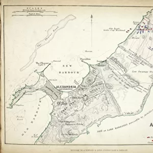
Map of the Battle of La Rothiere, published by William Blackwood and Sons, Edinburgh & London, 1848 (hand-coloured engraving)
")
![]()
Wall Art and Photo Gifts from Fine Art Finder
Map of the Battle of La Rothiere, published by William Blackwood and Sons, Edinburgh & London, 1848 (hand-coloured engraving)
746883 Map of the Battle of La Rothiere, published by William Blackwood and Sons, Edinburgh & London, 1848 (hand-coloured engraving) by Johnston, Alexander Keith (1804-71); Private Collection; (add.info.: Battle of La Rothiere (1 February 1814)); The Stapleton Collection; Scottish, out of copyright
Media ID 23484060
© The Stapleton Collection / Bridgeman Images
Aerial View Allies Armies Blucher Mapping Napoleon Positions Prussia Prussian
FEATURES IN THESE COLLECTIONS
> Aerial Photography
> Related Images
> Aerial Photography
> Scotland
> Arts
> Artists
> A
> William Alexander
> Arts
> Artists
> K
> William Keith
> Europe
> France
> Canton
> Allier
> Europe
> Russia
> Aerial Views
> Fine Art Finder
> Artists
> Alexander Keith Johnston
> Fine Art Finder
> Maps (celestial & Terrestrial)
EDITORS COMMENTS
This hand-coloured engraving, titled "Map of the Battle of La Rothiere" takes us back to a significant moment in history. Published by William Blackwood and Sons in Edinburgh & London in 1848, this print showcases the meticulous cartography skills of Alexander Keith Johnston. The map provides an aerial view of the Battle of La Rothiere, which took place on 1st February 1814 during the Napoleonic Wars. The detailed positions and movements depicted on this map allow us to visualize the strategic maneuvers undertaken by both Napoleon's army and their allied forces. As we examine this historic scene, we can see how France's armies clashed with those of Russia and Prussia. The French troops under Napoleon's command are represented alongside their Russian counterparts led by General Blucher. This visual representation highlights not only the scale but also the complexity of this battle. The artist's expert engraving techniques bring life to this historical document, allowing us to appreciate its artistic value as well as its informative purpose. With every stroke meticulously applied, Johnston has created a masterpiece that captures a crucial moment in European history. Now preserved within a private collection known as The Stapleton Collection, this remarkable piece offers us a glimpse into one chapter of warfare from the early nineteenth century. As we explore its intricate details and study each element carefully mapped out before our eyes, we gain insight into an era defined by conflict and alliances that shaped nations forevermore.
MADE IN THE USA
Safe Shipping with 30 Day Money Back Guarantee
FREE PERSONALISATION*
We are proud to offer a range of customisation features including Personalised Captions, Color Filters and Picture Zoom Tools
SECURE PAYMENTS
We happily accept a wide range of payment options so you can pay for the things you need in the way that is most convenient for you
* Options may vary by product and licensing agreement. Zoomed Pictures can be adjusted in the Cart.