Home > Historic > Ancient civilizations > Ancient Greece > Greek history
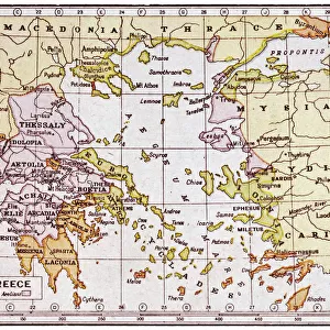
Map of Epirus and western Greece, 295 BC. From Cassells Universal History, published 1888

![]()
Wall Art and Photo Gifts from Design Pics
Map of Epirus and western Greece, 295 BC. From Cassells Universal History, published 1888
Design Pics offers Distinctively Different Imagery representing over 1,500 contributors
Media ID 24906861
© Ken Welsh
Ancient Cartography Geographical Geography Greece Greek
FEATURES IN THESE COLLECTIONS
> Europe
> Greece
> Related Images
> Historic
> Ancient civilizations
> Ancient Greece
> Greek history
> Maps and Charts
> Early Maps
> Maps and Charts
> Related Images
EDITORS COMMENTS
This print showcases a remarkable piece of history - the Map of Epirus and western Greece, dating back to 295 BC. Taken from Cassells Universal History, published in 1888, this ancient map offers a glimpse into the past and allows us to explore the geographical landscape of Greece during that period. The intricate details engraved on this archival piece provide an invaluable resource for historians and cartographers alike. It beautifully captures the essence of Greek culture and its significant influence on Western civilization. The careful craftsmanship evident in this vintage illustration transports us back in time, allowing us to visualize how these regions were shaped centuries ago. As we study this picture, we can't help but marvel at the historical significance it holds. It serves as a reminder of our collective heritage and provides insight into the political boundaries, cities, rivers, mountains, and other geographic features that defined Epirus and western Greece at that time. Ken Welsh's expertise is apparent in his preservation of such an important artifact through photography. This image not only preserves history but also sparks curiosity about ancient civilizations and their impact on our present-day world. Whether you are a lover of history or simply fascinated by ancient cultures, this print is sure to captivate your imagination as you delve into the rich tapestry of Greek geography from over two millennia ago.
MADE IN THE USA
Safe Shipping with 30 Day Money Back Guarantee
FREE PERSONALISATION*
We are proud to offer a range of customisation features including Personalised Captions, Color Filters and Picture Zoom Tools
SECURE PAYMENTS
We happily accept a wide range of payment options so you can pay for the things you need in the way that is most convenient for you
* Options may vary by product and licensing agreement. Zoomed Pictures can be adjusted in the Cart.