Home > North America > United States of America > South Carolina > Charleston
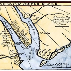
MAP: SOUTH CAROLINA, c1700. A Perticuler Map for the going into Ashley and Cooper Rivers

![]()
Wall Art and Photo Gifts from Granger
MAP: SOUTH CAROLINA, c1700. A Perticuler Map for the going into Ashley and Cooper Rivers
MAP: SOUTH CAROLINA, c1700.
A Perticuler Map for the going into Ashley and Cooper Rivers, showing the old and the new sites of Charleston and the adjacent plantations, c1700
Granger holds millions of images spanning more than 25,000 years of world history, from before the Stone Age to the dawn of the Space Age
Media ID 12568397
1700 Ashley Charleston Coast Colony Cooper South Carolina Southeastern United States
FEATURES IN THESE COLLECTIONS
> Arts
> Landscape paintings
> Waterfall and river artworks
> River artworks
> Granger Art on Demand
> U.S. States
> North America
> United States of America
> South Carolina
> Charleston
EDITORS COMMENTS
This print titled "MAP: SOUTH CAROLINA, c1700. A Perticuler Map for the going into Ashley and Cooper Rivers" takes us back in time to the early 18th century. The map showcases the intricate details of Charleston and its neighboring plantations during this period. The image transports us to a time when South Carolina was still a colony, with its southeastern coast brimming with potential and promise. The map provides a glimpse into the past, highlighting both the old and new sites of Charleston as well as the surrounding areas along Ashley and Cooper Rivers. As we study this historical artifact, we can't help but marvel at how much has changed since then. It serves as a reminder of our nation's rich history and how these landscapes have evolved over centuries. The artist behind this remarkable piece skillfully captures every minute detail, allowing us to appreciate the artistry involved in cartography during that era. From tracing river paths to marking plantation locations, each element on this map tells a story about South Carolina's colonial past. Whether you are an avid historian or simply intrigued by America's heritage, this print is sure to transport you back in time while igniting your curiosity about our country's roots.
MADE IN THE USA
Safe Shipping with 30 Day Money Back Guarantee
FREE PERSONALISATION*
We are proud to offer a range of customisation features including Personalised Captions, Color Filters and Picture Zoom Tools
SECURE PAYMENTS
We happily accept a wide range of payment options so you can pay for the things you need in the way that is most convenient for you
* Options may vary by product and licensing agreement. Zoomed Pictures can be adjusted in the Cart.