Home > Animals > Mammals > Cricetidae > Miletus
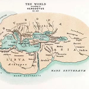
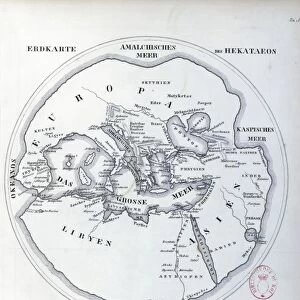
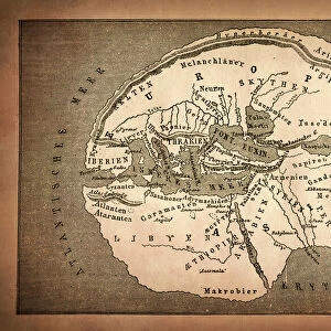
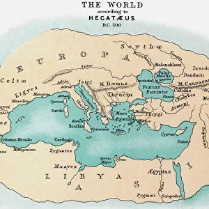
WORLD MAP: 500 B. C. Map of the world, c500 B. C. according to the writings of Hecataeus of Miletus, the reputed author of Travels around the World: a 19th

![]()
Wall Art and Photo Gifts from Granger
WORLD MAP: 500 B. C. Map of the world, c500 B. C. according to the writings of Hecataeus of Miletus, the reputed author of Travels around the World: a 19th
WORLD MAP: 500 B.C. Map of the world, c500 B.C. according to the writings of Hecataeus of Miletus, the reputed author of Travels around the World: a 19th century reconstruction
Granger holds millions of images spanning more than 25,000 years of world history, from before the Stone Age to the dawn of the Space Age
Media ID 6617351
Hellenic Republic Mediterranean World 500 Bc
FEATURES IN THESE COLLECTIONS
> Animals
> Mammals
> Cricetidae
> Miletus
> Arts
> Landscape paintings
> Waterfall and river artworks
> River artworks
> Granger Art on Demand
> Maps
> Maps and Charts
> Early Maps
> Maps and Charts
> World
EDITORS COMMENTS
This print takes us back in time to the ancient world of 500 B. C. It showcases a meticulously reconstructed map based on the writings of Hecataeus of Miletus, an esteemed author known for his work "Travels around the World". The map offers a glimpse into the geographical knowledge and understanding of that era. The intricate details depicted on this world map invite us to explore the vast territories and civilizations that once thrived. From the majestic Mediterranean Sea to winding rivers and sprawling landscapes, every element tells a story about our past. As we study this piece, we can almost imagine ourselves embarking on an epic journey through time. Hecataeus's influence is evident as he carefully documented his travels, providing valuable insights into various regions during his time. This reconstruction allows us to appreciate his contributions while also acknowledging that it was created in the 19th century by skilled cartographers who sought to bring history alive. As we gaze upon this remarkable artwork from Granger Art on Demand, let us marvel at how far humanity has come since those ancient times. It serves as a reminder of our shared heritage and inspires curiosity about cultures long gone but not forgotten. Whether you are an avid historian or simply captivated by artistry, this print is sure to transport you back in time and ignite your imagination with tales from centuries past.
MADE IN THE USA
Safe Shipping with 30 Day Money Back Guarantee
FREE PERSONALISATION*
We are proud to offer a range of customisation features including Personalised Captions, Color Filters and Picture Zoom Tools
SECURE PAYMENTS
We happily accept a wide range of payment options so you can pay for the things you need in the way that is most convenient for you
* Options may vary by product and licensing agreement. Zoomed Pictures can be adjusted in the Cart.