Home > North America > United States of America > New York > New York > Maps
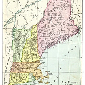
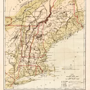
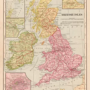
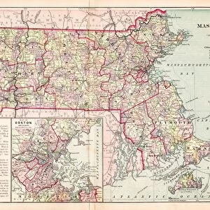
NEW ENGLAND MAP, c1775. Engraved map, c1775, of colonial New England

![]()
Wall Art and Photo Gifts from Granger
NEW ENGLAND MAP, c1775. Engraved map, c1775, of colonial New England
NEW ENGLAND MAP, c1775. Engraved map, c1775, of colonial New England, thought to be the last such map printed before the American Revolutionary War
Granger holds millions of images spanning more than 25,000 years of world history, from before the Stone Age to the dawn of the Space Age
Media ID 6616339
1775 Colony Connecticut Massachusetts New Hampshire New York Rhode Island Vermont
FEATURES IN THESE COLLECTIONS
> Arts
> Landscape paintings
> Waterfall and river artworks
> River artworks
> Europe
> United Kingdom
> England
> Hampshire
> Related Images
> Europe
> United Kingdom
> England
> Maps
> Europe
> United Kingdom
> England
> Rivers
> Europe
> United Kingdom
> England
> York
> Granger Art on Demand
> Maps
> Maps and Charts
> Related Images
> North America
> United States of America
> New York
> New York
> Maps
EDITORS COMMENTS
This print showcases a remarkable piece of history - the "NEW ENGLAND MAP, c1775". Engraved with precision and care, this map offers a glimpse into colonial New England during a pivotal time in American history. Believed to be the final map printed before the outbreak of the American Revolutionary War, it holds immense significance. The intricate details on this engraved map transport us back to a bygone era. From the bustling streets of New York to the picturesque landscapes of Massachusetts and Connecticut, every colony is meticulously depicted. The inclusion of Vermont, North Rhode Island, and New Hampshire further enriches our understanding of this region's historical boundaries. As we explore this extraordinary artwork from The Granger Collection, we can't help but marvel at its historical importance. It serves as a tangible reminder of how these colonies were interconnected long before they became states united under one flag. Whether you are an avid historian or simply appreciate art that tells stories from our past, this print is sure to captivate your imagination. Display it proudly in your home or office space as a testament to America's rich heritage and the enduring spirit that shaped our nation.
MADE IN THE USA
Safe Shipping with 30 Day Money Back Guarantee
FREE PERSONALISATION*
We are proud to offer a range of customisation features including Personalised Captions, Color Filters and Picture Zoom Tools
SECURE PAYMENTS
We happily accept a wide range of payment options so you can pay for the things you need in the way that is most convenient for you
* Options may vary by product and licensing agreement. Zoomed Pictures can be adjusted in the Cart.