Home > Maps and Charts > Related Images
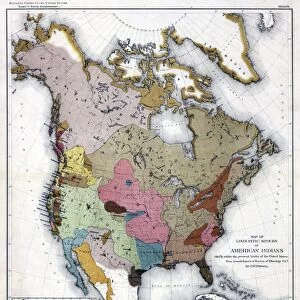
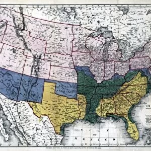
MAP: RESERVATIONS, 1888. Map showing the location of the Indian reservations within

![]()
Wall Art and Photo Gifts from Granger
MAP: RESERVATIONS, 1888. Map showing the location of the Indian reservations within
MAP: RESERVATIONS, 1888.
Map showing the location of the Indian reservations within the limits of the United States and territories. Lithograph, 1888
Granger holds millions of images spanning more than 25,000 years of world history, from before the Stone Age to the dawn of the Space Age
Media ID 12321311
1888 American Indian Indian Affairs Reservation United States
FEATURES IN THESE COLLECTIONS
> Granger Art on Demand
> Maps
> Maps and Charts
> Related Images
MAP - RESERVATIONS, 1888. Map showing the location of the Indian reservations within the limits of the United States and territories. Lithograph, 1888
EDITORS COMMENTS
. This lithograph from 1888 offers a historical glimpse into American Indian affairs during a crucial period in United States history. The intricate map showcases the vast network of Indian reservations scattered across the country at that time, providing valuable insight into their geographical distribution. The attention to detail in this lithograph is truly remarkable; each reservation is meticulously marked and labeled, allowing viewers to appreciate both its artistic beauty and informational significance. It serves as a visual testament to the complex relationship between Native Americans and settlers during this era. As we delve into this piece by Granger Art on Demand, we are transported back to late 19th-century America—a time when these reservations played a pivotal role in shaping indigenous communities' lives amidst rapid territorial expansion. This print not only documents an important chapter in American history but also highlights ongoing efforts towards understanding and preserving Native American heritage. Granger's expertise shines through once again with their impeccable collection—this particular artwork seamlessly captures both cultural importance and aesthetic appeal. Whether you're an art enthusiast or a history buff, "MAP: RESERVATIONS, 1888" will undoubtedly captivate your imagination while shedding light on an often overlooked aspect of our nation's past.
MADE IN THE USA
Safe Shipping with 30 Day Money Back Guarantee
FREE PERSONALISATION*
We are proud to offer a range of customisation features including Personalised Captions, Color Filters and Picture Zoom Tools
SECURE PAYMENTS
We happily accept a wide range of payment options so you can pay for the things you need in the way that is most convenient for you
* Options may vary by product and licensing agreement. Zoomed Pictures can be adjusted in the Cart.