Home > Maps and Charts > World
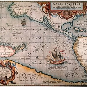
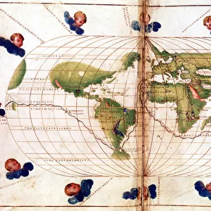
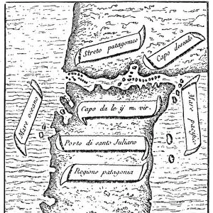
MAP: MAGELLANs VOYAGE. Gore-map showing Ferdinand Magellans circumnavigation of the globe

![]()
Wall Art and Photo Gifts from Granger
MAP: MAGELLANs VOYAGE. Gore-map showing Ferdinand Magellans circumnavigation of the globe
MAP: MAGELLANs VOYAGE.
Gore-map showing Ferdinand Magellans circumnavigation of the globe, 1519-1522
Granger holds millions of images spanning more than 25,000 years of world history, from before the Stone Age to the dawn of the Space Age
Media ID 12321189
Age Of Discovery Circumnavigation Ferdinand Globe Magellan New World Portuguese Sailing Spanish Voyage World Gore
FEATURES IN THESE COLLECTIONS
> Granger Art on Demand
> Maps
> Maps and Charts
> World
EDITORS COMMENTS
This print showcases a historical masterpiece, the "MAP: MAGELLANs VOYAGE". A true gem from the 16th century, this gore-map vividly depicts Ferdinand Magellan's extraordinary circumnavigation of the globe between 1519 and 1522. Intricate details come to life in this drawing, transporting us back to the age of discovery when brave explorers like Magellan embarked on daring voyages into uncharted territories. The map serves as a testament to human curiosity and ambition during the Renaissance period. Magellan's voyage was an epic undertaking that forever changed our understanding of the world. As we gaze upon this print, we are reminded of his audacious spirit and determination to explore new horizons. It symbolizes not only his personal journey but also represents mankind's relentless quest for knowledge and adventure. The map reveals both known and unknown lands at that time, providing glimpses into exotic places yet to be fully explored by Europeans. It highlights key locations such as ports visited along the way, offering insights into how early sailors navigated vast oceans with limited tools. With its rich colors and intricate illustrations, this print captures our imagination while honoring one of history's greatest achievements in exploration. Whether you're a history enthusiast or simply appreciate fine artistry, this piece is sure to spark conversations about humanity's insatiable desire for discovery.
MADE IN THE USA
Safe Shipping with 30 Day Money Back Guarantee
FREE PERSONALISATION*
We are proud to offer a range of customisation features including Personalised Captions, Color Filters and Picture Zoom Tools
SECURE PAYMENTS
We happily accept a wide range of payment options so you can pay for the things you need in the way that is most convenient for you
* Options may vary by product and licensing agreement. Zoomed Pictures can be adjusted in the Cart.