Home > North America > Jamaica > Maps
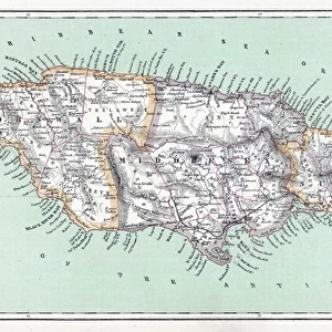
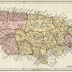
MAP: JAMAICA, 1755. British map of Jamaica from surveys by Mr. Sheffield, drawn by Patrick Browne

![]()
Wall Art and Photo Gifts from Granger
MAP: JAMAICA, 1755. British map of Jamaica from surveys by Mr. Sheffield, drawn by Patrick Browne
MAP: JAMAICA, 1755.
British map of Jamaica from surveys by Mr. Sheffield, drawn by Patrick Browne, 1755
Granger holds millions of images spanning more than 25,000 years of world history, from before the Stone Age to the dawn of the Space Age
Media ID 12321396
1755 British Browne Island Jamaica Patrick Port Royal Sheffield
FEATURES IN THESE COLLECTIONS
> Granger Art on Demand
> Maps
> Maps and Charts
> Related Images
> North America
> Jamaica
> Maps
EDITORS COMMENTS
This print showcases a historical British map of Jamaica from the year 1755. The map was meticulously crafted by Mr. Sheffield, based on surveys conducted on the island. It was then skillfully drawn by Patrick Browne, who brought this intricate piece to life with his artistic talent. The map provides a fascinating glimpse into Jamaica's past, depicting various landmarks and locations that were significant during that time period. Fort Charles stands proudly in one corner of the map, symbolizing the island's military strength and strategic importance. With its sepia tones and detailed engravings, this print exudes an air of nostalgia and elegance. It transports viewers back to a time when cartography was both an art form and a scientific endeavor. From Port Royal to mid-island regions, every inch of Jamaica is intricately represented on this historic map. The inclusion of text adds further context and information about the different areas depicted. Whether you are a history enthusiast or simply appreciate fine craftsmanship, this print is sure to captivate your imagination. Display it in your home or office as a conversation starter or as a reminder of Jamaica's rich heritage.
MADE IN THE USA
Safe Shipping with 30 Day Money Back Guarantee
FREE PERSONALISATION*
We are proud to offer a range of customisation features including Personalised Captions, Color Filters and Picture Zoom Tools
SECURE PAYMENTS
We happily accept a wide range of payment options so you can pay for the things you need in the way that is most convenient for you
* Options may vary by product and licensing agreement. Zoomed Pictures can be adjusted in the Cart.