Home > Maps and Charts > Americas
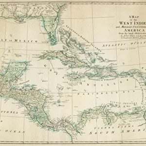
MAP: GULF COAST, 1747. Carte general de toute la cote de la Louisianne... by Alexandre de Batz

![]()
Wall Art and Photo Gifts from Granger
MAP: GULF COAST, 1747. Carte general de toute la cote de la Louisianne... by Alexandre de Batz
MAP: GULF COAST, 1747.
Carte general de toute la cote de la Louisianne... by Alexandre de Batz, 1747
Granger holds millions of images spanning more than 25,000 years of world history, from before the Stone Age to the dawn of the Space Age
Media ID 12321257
1747 Compass Rose Florida Gulf Coast Gulf Of Mexico Louisiana United States Southeast
FEATURES IN THESE COLLECTIONS
> Granger Art on Demand
> Maps
> North America
> Mexico
> Maps
EDITORS COMMENTS
This print showcases a historical map titled "MAP: GULF COAST, 1747. Carte general de toute la cote de la Louisianne. . . by Alexandre de Batz". Created in 1747, this remarkable piece of cartography offers a glimpse into the past and provides valuable insights into the geography of the Gulf Coast region. The map encompasses an expansive area, stretching from Florida to Louisiana and covering the entire Gulf Coast. Its intricate details depict various landmarks, rivers, and settlements that were significant during that era. The inclusion of a compass rose adds an element of authenticity and highlights the navigational importance of this map. As we delve into its intricacies, we can appreciate how it serves as a testament to America's rich history. This artifact not only represents an important milestone in cartographic development but also sheds light on early American exploration and settlement along these coastal areas. With its muted colors and delicate text inscriptions, this print transports us back to a time when maps were meticulously hand-drawn works of art. It is truly fascinating to observe how our understanding of geography has evolved over centuries. Thanks to Granger Art on Demand's preservation efforts, we are fortunate enough to have access to such historically significant pieces like this one. Whether you are an avid historian or simply appreciate fine artistry, this print is sure to captivate your imagination with its depiction of America's Gulf Coast in 1747.
MADE IN THE USA
Safe Shipping with 30 Day Money Back Guarantee
FREE PERSONALISATION*
We are proud to offer a range of customisation features including Personalised Captions, Color Filters and Picture Zoom Tools
SECURE PAYMENTS
We happily accept a wide range of payment options so you can pay for the things you need in the way that is most convenient for you
* Options may vary by product and licensing agreement. Zoomed Pictures can be adjusted in the Cart.