Home > Maps and Charts > Related Images
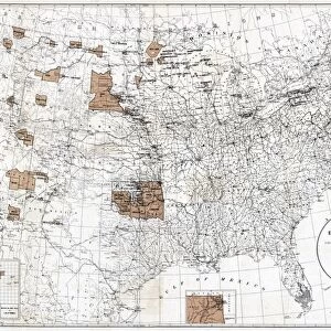
MAP: CIVIL WAR, 1864. Map of the United States, showing the territory in possession

![]()
Wall Art and Photo Gifts from Granger
MAP: CIVIL WAR, 1864. Map of the United States, showing the territory in possession
MAP: CIVIL WAR, 1864.
Map of the United States, showing the territory in possession of the Federal Union, January, 1864
Granger holds millions of images spanning more than 25,000 years of world history, from before the Stone Age to the dawn of the Space Age
Media ID 12321341
FEATURES IN THESE COLLECTIONS
> Granger Art on Demand
> Maps
> Maps and Charts
> Related Images
EDITORS COMMENTS
This lithograph, titled "MAP: CIVIL WAR, 1864" offers a visual representation of the United States during a pivotal moment in history. Created by Granger, NYC and part of The Granger Collection, this print showcases the territorial divisions that defined the American Civil War in January 1864. The map itself is meticulously detailed, providing an intricate snapshot of the nation's landscape during this tumultuous period. It vividly illustrates which territories were under the control of the Federal Union at that specific time. With its crisp lines and precise labeling, it serves as both a historical artifact and a testament to human conflict. The image transports us back to mid-19th century America when tensions between North and South reached their peak. As we examine this lithograph closely, we can almost feel the weight of uncertainty hanging over each state depicted on its surface. It reminds us of how deeply divided our country once was and how these divisions ultimately led to one of our nation's bloodiest conflicts. This piece from Granger Art on Demand allows us to reflect upon our past while appreciating the artistry involved in creating such an informative document. Whether you are a history enthusiast or simply intrigued by cartography, "MAP: CIVIL WAR, 1864" provides an engaging glimpse into America's struggle for unity during one of its most challenging periods.
MADE IN THE USA
Safe Shipping with 30 Day Money Back Guarantee
FREE PERSONALISATION*
We are proud to offer a range of customisation features including Personalised Captions, Color Filters and Picture Zoom Tools
SECURE PAYMENTS
We happily accept a wide range of payment options so you can pay for the things you need in the way that is most convenient for you
* Options may vary by product and licensing agreement. Zoomed Pictures can be adjusted in the Cart.