Home > Asia > Malaysia > Maps
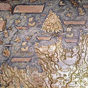
MAP OF BORNEO, 1595. Detail of Borneo from Peter Plancius chart of the Moluccas

![]()
Wall Art and Photo Gifts from Granger
MAP OF BORNEO, 1595. Detail of Borneo from Peter Plancius chart of the Moluccas
MAP OF BORNEO, 1595.
Detail of Borneo from Peter Plancius chart of the Moluccas, or Spice Islands, published in 1595 at Amsterdam
Granger holds millions of images spanning more than 25,000 years of world history, from before the Stone Age to the dawn of the Space Age
Media ID 12321096
1595 Detail Indonesian Malaysia Pieter Portolan Chart Borneo Spice Islands
FEATURES IN THESE COLLECTIONS
> Granger Art on Demand
> Maps
> Maps and Charts
> Related Images
EDITORS COMMENTS
This print showcases a remarkable piece of cartographic history - the "Map of Borneo, 1595". With its intricate details and historical significance, this image transports us back to the era of exploration and discovery. Taken from Peter Plancius' chart of the Moluccas, also known as the Spice Islands, this particular detail focuses on Borneo. The map was published in Amsterdam in 1595, making it an invaluable artifact that offers insights into the geographical knowledge of that time. The viewer is immediately drawn to the exquisite craftsmanship and attention to detail evident in every inch of this map. It vividly depicts both Indonesian and Malaysian territories within Borneo's boundaries. The intricate lines and symbols provide a visual representation not only for navigational purposes but also for understanding trade routes during this period. As we gaze upon this print, we can't help but appreciate Pieter Plancius' expertise in creating such an accurate portrayal of Borneo's geography. This masterpiece serves as a testament to the importance placed on mapping during an age when exploration was key to expanding empires and acquiring valuable resources. Whether you are a history enthusiast or simply captivated by beautiful works of art, this print is sure to transport you back in time while igniting your curiosity about our world's past.
MADE IN THE USA
Safe Shipping with 30 Day Money Back Guarantee
FREE PERSONALISATION*
We are proud to offer a range of customisation features including Personalised Captions, Color Filters and Picture Zoom Tools
SECURE PAYMENTS
We happily accept a wide range of payment options so you can pay for the things you need in the way that is most convenient for you
* Options may vary by product and licensing agreement. Zoomed Pictures can be adjusted in the Cart.