Home > North America > United States of America > Massachusetts > Boston
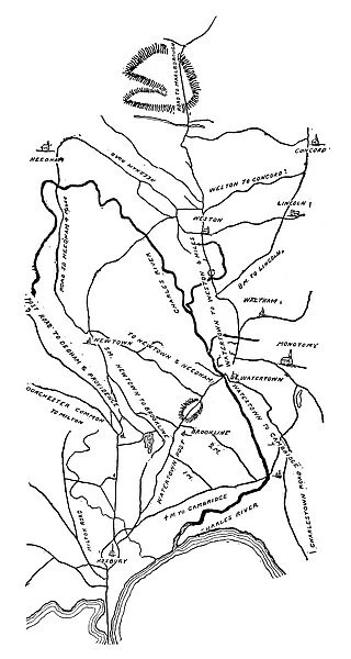
Manuscript map, 1775, of the Massachusetts countryside between Boston and Concord drawn by an agent of British General (and Governor) Thomas Gage
![]()

Wall Art and Photo Gifts from Granger
Manuscript map, 1775, of the Massachusetts countryside between Boston and Concord drawn by an agent of British General (and Governor) Thomas Gage
BOSTON-CONCORD MAP, 1775.
Manuscript map, 1775, of the Massachusetts countryside between Boston and Concord drawn by an agent of British General (and Governor) Thomas Gage
Granger holds millions of images spanning more than 25,000 years of world history, from before the Stone Age to the dawn of the Space Age
Media ID 7963867
1775 American Revolution Boston Concord Gage Governor Manuscript Rebellion Revolutionary United States
FEATURES IN THESE COLLECTIONS
> Arts
> Landscape paintings
> Waterfall and river artworks
> River artworks
> Granger Art on Demand
> American Revolution
> North America
> United States of America
> Massachusetts
> Boston
EDITORS COMMENTS
This print showcases a remarkable piece of history - the Manuscript map of the Massachusetts countryside between Boston and Concord, drawn in 1775 by an agent of British General (and Governor) Thomas Gage. This intricately detailed map offers a glimpse into the landscape that played a pivotal role in the American Revolution. As tensions escalated between England and its North American colonies, this map served as a strategic tool for General Gage to navigate and understand the terrain he would encounter during military operations. It provides invaluable insight into the geographical features, roads, rivers, and towns that shaped the region at that time. The significance of this manuscript extends beyond its cartographic value. It symbolizes both British authority over colonial territories and the growing rebellion among Americans seeking independence from English rule. The events depicted on this map would eventually lead to one of history's most transformative moments - the birth of a new nation: The United States of America. Through this image, we are transported back to an era when lines were being drawn both on paper and in society. It serves as a reminder of our shared past and invites us to reflect upon how far we have come since those revolutionary times.
MADE IN THE USA
Safe Shipping with 30 Day Money Back Guarantee
FREE PERSONALISATION*
We are proud to offer a range of customisation features including Personalised Captions, Color Filters and Picture Zoom Tools
SECURE PAYMENTS
We happily accept a wide range of payment options so you can pay for the things you need in the way that is most convenient for you
* Options may vary by product and licensing agreement. Zoomed Pictures can be adjusted in the Cart.


