Home > North America > United States of America > Virginia > Chesapeake
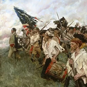
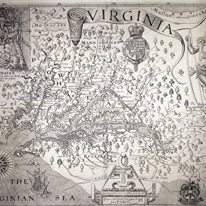
Battle of Virginia Capes between the French and English fleets, 5-10 September 1781. The positions of the British and French fleets before the action. Sketch from a contemporary English magazine

![]()
Wall Art and Photo Gifts from Granger
Battle of Virginia Capes between the French and English fleets, 5-10 September 1781. The positions of the British and French fleets before the action. Sketch from a contemporary English magazine
BATTLE OF VIRGINIA CAPES.
Battle of Virginia Capes between the French and English fleets, 5-10 September 1781. The positions of the British and French fleets before the action. Sketch from a contemporary English magazine
Granger holds millions of images spanning more than 25,000 years of world history, from before the Stone Age to the dawn of the Space Age
Media ID 10409742
1781 American Revolution Battle Cape Chesapeake Bay Continental Army Continental Navy Fleet Plan Rebellion Revolutionary Royal Navy September Southeastern United States Virginia Yorktown
FEATURES IN THESE COLLECTIONS
> Arts
> Contemporary art
> Arts
> Literature
> Magazines
> Arts
> Pop art
> Contemporary art
> Contemporary art gallery
> Granger Art on Demand
> American Revolution
> Granger Art on Demand
> Plans and Diagrams
> North America
> United States of America
> Virginia
> Chesapeake
EDITORS COMMENTS
This print captures the intense Battle of Virginia Capes that took place between the French and English fleets from 5th to 10th September 1781. The sketch, sourced from a contemporary English magazine, depicts the positions of both fleets before the action commenced. In this historic battle, which played a pivotal role in the American Revolution, we witness the clash between two naval powerhouses - the Royal Navy representing England and its formidable adversary, France. Set against the backdrop of Cape Henry in Virginia, this image transports us back to a time when these nations fought for control over America's destiny. The strategic positioning of each fleet is meticulously illustrated on this plan-like map. As tensions rise and anticipation fills the air, one can almost feel the weight of rebellion hanging over Chesapeake Bay. It was here that General Cornwallis' British forces found themselves trapped by land and sea during their ill-fated campaign at Yorktown. This visual testament serves as a reminder of how crucial naval dominance was during this era-defining conflict. The Continental Army's success relied heavily on support from their French allies who sought to secure American independence against British rule. As we gaze upon this remarkable piece of history frozen in time, it evokes feelings of admiration for those who fought valiantly for freedom and reminds us that battles are not only won on land but also at sea.
MADE IN THE USA
Safe Shipping with 30 Day Money Back Guarantee
FREE PERSONALISATION*
We are proud to offer a range of customisation features including Personalised Captions, Color Filters and Picture Zoom Tools
SECURE PAYMENTS
We happily accept a wide range of payment options so you can pay for the things you need in the way that is most convenient for you
* Options may vary by product and licensing agreement. Zoomed Pictures can be adjusted in the Cart.